Capture is the start. AIM is what comes next.
Nationwide Drones is the services brand. AIM Platform is the technology brand, and an official RICS Tech Partner. Same parent company, same team, same office. We capture the data, AIM makes it useful.
Nationwide Drones is the services brand. AIM Platform is the technology brand, and an official RICS Tech Partner. Same parent company, same team, same office. We capture the data, AIM makes it useful.
For years, we delivered high-quality drone capture to clients who then had nowhere to put it. Survey data ended up in shared drives, attached to forgotten emails, or trapped in proprietary desktop software that only one person in the organisation had access to.
The capture work was great. The afterlife of the data wasn't. So we built AIM Platform, software that hosts, processes and shares everything we capture, with unlimited users and no per-seat licensing.
AIM is now an official Royal Institution of Chartered Surveyors (RICS) Technology Partner, used by surveying practices, consultants, housing providers, councils, healthcare estates, contractors, universities, and developers across the UK. It's the system of record for every Nationwide Drones engagement, and it's available as a standalone platform for organisations who want to centralise their own asset data.
Visual, thermal and laser sensors flown by surveyor-led operators. Capture sized to the job and the deliverable required.
Photogrammetry, point clouds, thermal overlays and 360 stitching processed and registered to the building model.
Hosted, shareable, measurable in a browser. Unlimited users, no per-seat costs, ready for the next site visit replacement.
AIM Platform breaks into four products, each mapped to a stage of the capture-to-delivery journey. Every Nationwide Drones engagement uses one or more.
Hosts 360 tours, virtual walk-throughs and immersive content. Used for 360 capture, drone media and combined ground-and-air engagements.
See AIM Capture →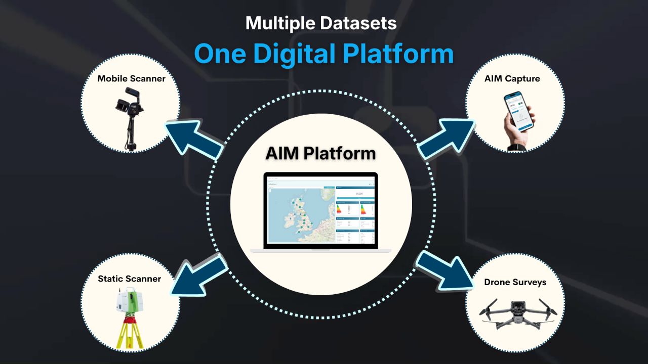
Hosts photogrammetric models, point clouds, thermal data and time-series captures. Used for surveys, thermography, laser scanning and construction monitoring.
See AIM Hosting →
Holds the drawn deliverables: floor plans, elevations, sections, condition reports. Linked back to the capture they came from.
See AIM Projects →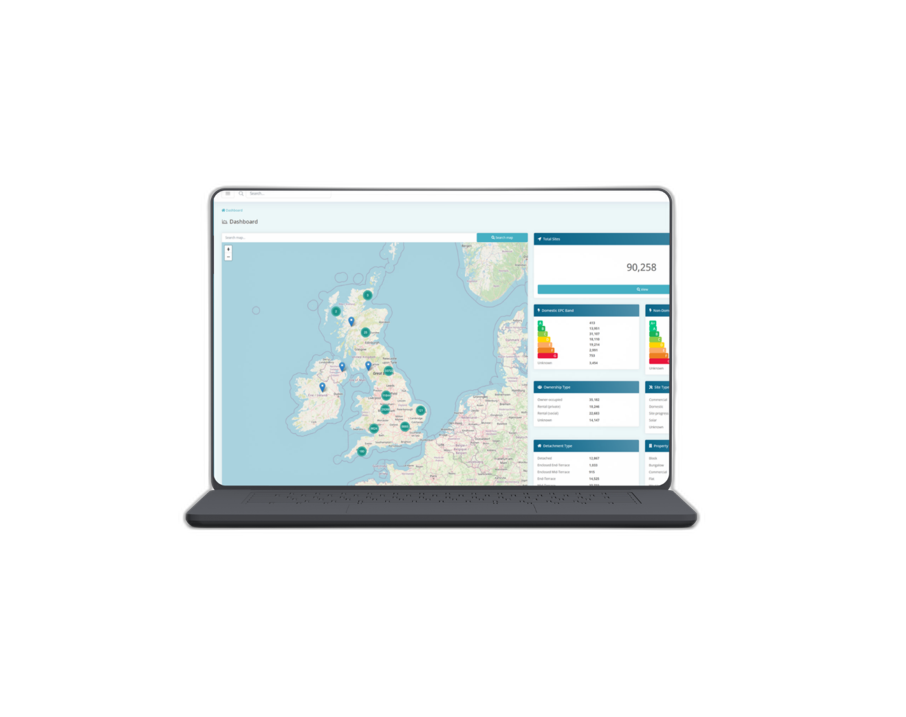
The full asset information platform. Standalone subscription for organisations that want to centralise all of their asset data, not just what we capture.
See the platform →Rooflines, high ceilings, and external elevations. Captured from the ground.
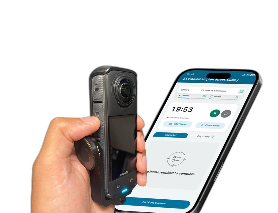
Extend the 360° camera on a carbon pole and you're up at gutter and roof height in seconds. No CAA licence, no qualified pilot, no weather window. Works on any building type, and your team can run it without us on site.

Now in reach. With carbon pole options extending up to 10 metres, most two and three-storey buildings are fully within range. Rooflines, gutters, high ceilings, external elevations, and upper storeys, all captured from the ground with the kit already in your bag.
For the captures a pole can't reach, structures above 10m, large area mapping, thermal work, BVLOS inspections, complex airspace, that's when we bring in the drone team.
Talk to us about combined capture →Replacing site visits with hosted captures changes the unit economics of asset inspection. These are the figures AIM clients consistently report.
AIM Platform holds certifications and partnerships that matter for working with professional surveying practices, public sector clients, and tier-one contractors. These are the credentials that pass procurement.
Official technology partner of the Royal Institution of Chartered Surveyors. Recognised solution provider for chartered practices.
Gold-level pre-qualified supplier. Health and safety, financial, environmental and compliance standards verified annually.
UK Government-backed cyber security certification. Your captured data is hosted to recognised information security standards.
Nationwide Drones and AIM Platform are both trading styles of AIM Housing Limited. Same founders, same office, same team. We capture, AIM delivers.